Agricultural Stress Index (ASI)
This map shows the actual situation of the vegetation in the Departament of Puno, as reflected by the the Agricultural Stress Index (ASI).
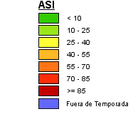
Table 1: Range of percentage of affected area
This index is available for different types of crops: Fodder Oats, Potato, Quinoa, Fodder Barley. Select the crop type of your interest in the Menu > Type of Crop.
Agricultural Stress Index
The Agricultural Stress Index (ASI) is an index based on the integration of the Vegetation Health Index (VHI) in two dimensions that are critical in the assessment of a drought event in agriculture: temporal and spatial. The first step of the ASI calculation is a temporal averaging of the VHI, assessing the intensity and duration of dry periods occurring during the crop cycle at pixel level. The second step determines the spatial extent of drought events by calculating the percentage of pixels in arable areas with a VHI value below 35 percent (this value was identified as a critical threshold in assessing the extent of drought in previous research by Kogan, 1995). Finally, each administrative area is classified according to its percentage of affected area to facilitate the quick interpretation of results by analysts.
Dataset Documentation
Helpdesks
Contact : snirh@ana.gob.pe