Combined Drought Index
This map shows the Combined Drought Index (CDI). This variable shows actual drought conditions for Peru.
The Combined Drought Index combines meteorological indicators of drought (Standardized Precipitation Index, SPI), agricultural drought (anomaly NDVI). In this way it is possible to reduce false alarms of drought. The CDI provides a holistic view of the drought situation using a specific classification. The CDI considers three levels of impact with each three intensity levels:
Table 1: Criteria of classification of CDI
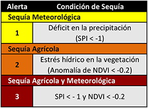
The CDI considers three levels of impact with each three intensity levels:
Dataset Documentation
Índice de Precipitación Estandarizada (SPI), entregado por SENAMHI (SENAMHI)
Helpdesk
Contact: snirh@ana.gob.pe